Drone & Aerial Photography
in Huntsville, AL
Professional drone photography and 4K aerial video for real estate, construction, and commercial projects across the Tennessee Valley.
FAA
Part 107 Certified Pilots
4K
Aerial Video Resolution
48MP
Drone Still Photography
68%
More Views: Drone Listings
Huntsville's Premier Drone Photography Company
Huntsville, Alabama sits at the intersection of natural beauty and rapid development. From the sweeping ridgelines of Monte Sano to the manicured golf fairways of Hampton Cove, from the Tennessee River waterfront at Wheeler Lake to the expanding neighborhoods of Madison and the new aerospace infrastructure emerging across the region — North Alabama is a landscape that begs to be seen from above.
Drone photography has become a cornerstone of professional real estate marketing, construction documentation, and commercial visual storytelling. But not all drone photography is equal. Camera quality, pilot skill, post-production expertise, and — critically — legal compliance all separate professional aerial imagery from the kind that creates liability problems and disappointing results.
At Launch Production & Design, our drone pilots hold FAA Part 107 Remote Pilot Certificates, operate commercial-grade aircraft with up to 48MP sensor resolution and 4K video capability, and bring years of aerial photography experience to every shoot. We handle airspace authorization, weather planning, and post-processing — delivering finished images and video that are ready to use, not a folder of raw files for you to sort through.
Why FAA Certification Matters
In Alabama, commercial drone flights — which includes any photography used for business purposes — require FAA Part 107 certification. Operating without it creates legal exposure for you and your clients. Every flight by Launch Production & Design is conducted by a licensed pilot with appropriate insurance. You're protected.
FAA Certification & Compliance: Why It Matters for Your Business
The Federal Aviation Administration requires anyone operating a drone for commercial purposes to hold a Part 107 Remote Pilot Certificate. This means studying airspace regulations, weather patterns, drone systems, emergency procedures, and a host of other topics — then passing a proctored FAA exam. It's a meaningful credential that separates professionals from hobbyists.
For real estate agents and brokers, hiring an uncertified drone operator isn't just a quality risk — it's a legal one. The FAA can issue fines for unlicensed commercial drone operations, and some real estate boards have established rules about using illegally obtained drone footage in listings.
When you book drone photography through Launch Production & Design, you're working with pilots who:
- Hold current FAA Part 107 Remote Pilot Certificates
- Carry commercial drone liability insurance
- Obtain LAANC approvals for controlled airspace when required
- Check airspace boundaries before every flight
- Follow Temporary Flight Restrictions around Redstone Arsenal
Drone & Aerial Photography Services We Offer
Real Estate Aerial Photography
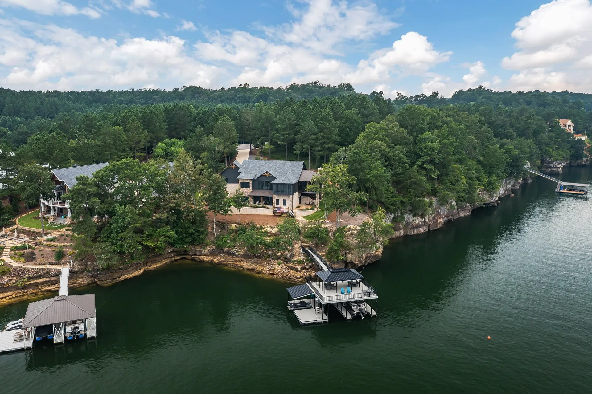
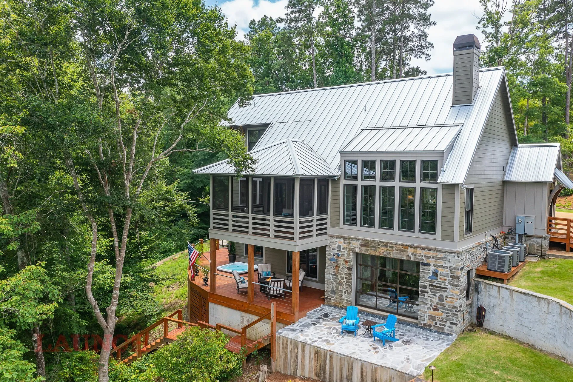
Stunning overhead and oblique aerial stills that showcase lot size, neighborhood context, proximity to amenities, and curb appeal from angles buyers never forget. Our most requested service for listings in Hampton Cove, Monte Sano, Big Cove, and waterfront properties along Wheeler Lake.
4K Aerial Video
Cinematic aerial video that flows over and around your listing, capturing the property in motion. Perfect for luxury listings, large acreage, waterfront, and any property where the surrounding environment is a selling point. Delivered edited and ready for MLS, YouTube, and social.
Construction Progress Documentation
Regular aerial photography sessions that document construction progress from pad-pour through topping out and completion. Essential for developers, builders, and lenders who need visual records for financing, marketing, and project management. Consistent perspectives and timestamps ensure a compelling progress sequence.
Commercial Aerial Photography
Industrial facilities, retail centers, office parks, distribution warehouses, and mixed-use developments photographed to impress investors, tenants, and stakeholders. We understand how to frame commercial properties to emphasize scale, access, and strategic value.
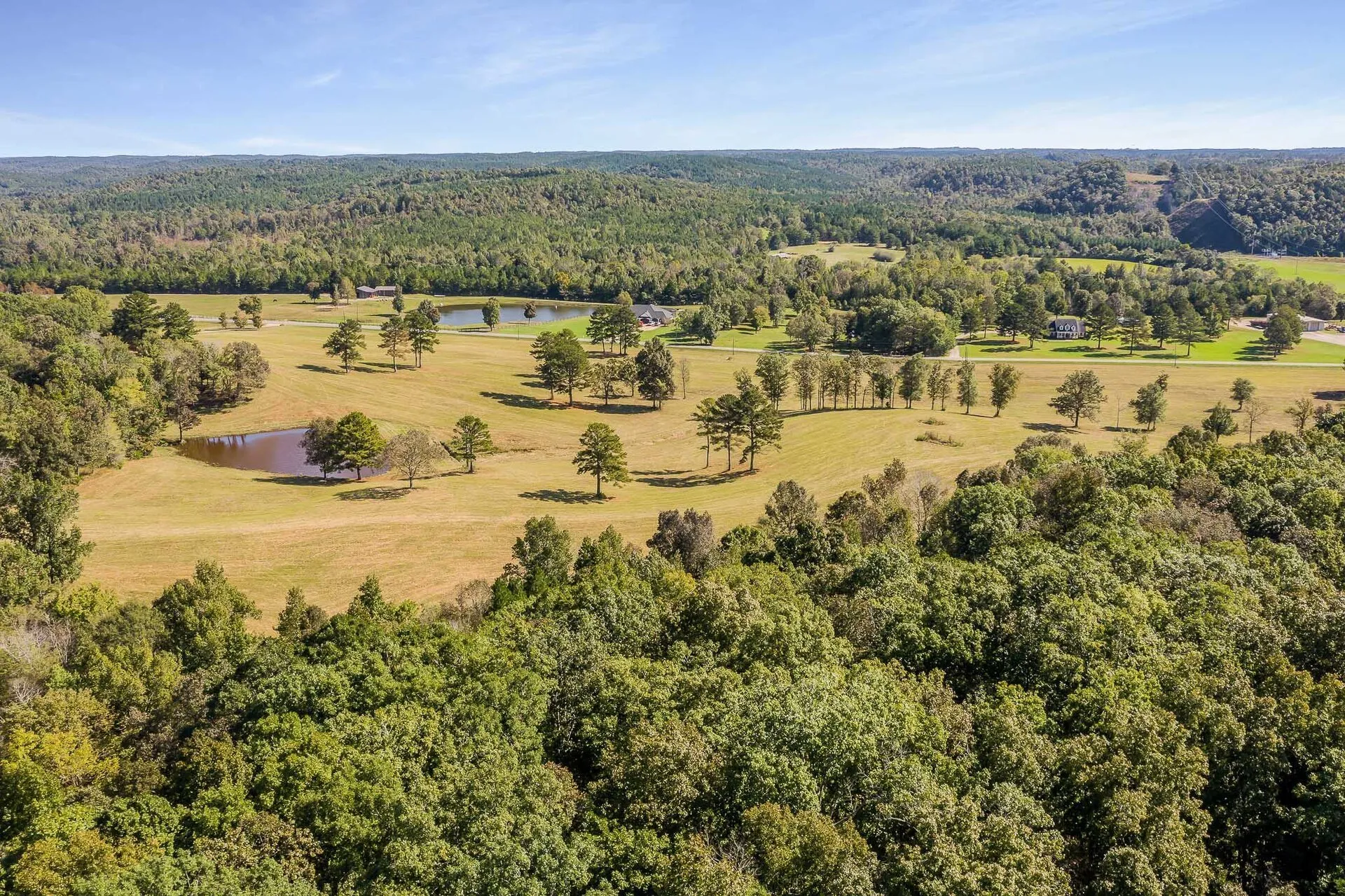
Land & Acreage Photography
Vacant land, farm tracts, and large acreage listings are nearly impossible to represent effectively without aerial photography. We map your land with overhead coverage that clearly shows boundaries, topography, water features, road access, and surrounding context — turning a flat legal description into a compelling visual property story.
Event & Community Aerial Coverage
Community events, grand openings, sporting events, and development celebrations covered from above. Drone coverage creates social-media-ready content that ground photographers simply cannot match for impact and reach.
Drone Photography Across Huntsville's Distinctive Landscapes
Huntsville's geography is surprisingly varied for a mid-sized city. The Tennessee Valley floor sits alongside Keel Mountain, Monte Sano, and the eastern ridgelines — creating dramatic elevation changes and scenic backdrops that drone photography captures beautifully.
Hampton Cove & Golf Course Properties
Hampton Cove's scenic terrain — backing up to Robert Trent Jones Golf Trail's Hampton Cove courses and framed by mountain ridgelines — creates the perfect aerial photography environment. Shots from above show the golf course setting, the community layout, and the natural backdrop in a way that makes luxury listings in this corridor genuinely aspirational.
Monte Sano Mountain Properties
Monte Sano presents interesting drone photography logistics — elevated terrain, tree canopy, and proximity to Monte Sano State Park — but the payoff is extraordinary. Aerial shots from Monte Sano can frame a property against the city skyline of Huntsville below, creating contrast between natural privacy and urban proximity.
Wheeler Lake & Tennessee River Waterfront
Waterfront properties from the Big Cove area down through Wheeler Lake in Morgan County are among the most drone-photography-dependent listings in North Alabama. Water access, dock configuration, lake frontage footage, and the relationship between a property and the water are nearly impossible to communicate without aerial shots.
Cummings Research Park & Commercial Corridor
Cummings Research Park — the second-largest research park in the country — and the surrounding commercial development corridors along I-565, Research Park Boulevard, and the Madison industrial areas are increasingly important subjects for commercial aerial photography.
Our Drone Photography Process
From your first call to final file delivery, we handle every aspect of the aerial photography process so you don't have to think about it.
1. Book & Brief
Book online or call (256)-429-2233. We gather property details, your goals for the shoot, and any specific angles or features to emphasize. We check airspace restrictions and weather windows for your location.
2. Airspace Authorization
For locations requiring LAANC authorization or near controlled airspace, we handle the FAA clearance process before arriving on site. You never need to worry about the regulatory side.
3. On-Site Flight Operations
Our pilot arrives, conducts a pre-flight safety check, and captures your property from multiple altitudes and angles. We communicate with you throughout to ensure we're capturing your priorities.
4. Professional Editing & Delivery
Raw aerial footage is professionally edited — color-graded, exposure-balanced, and cropped. Finished files delivered via online gallery within 24–48 hours in MLS-ready and social-media-ready formats.
Drone Photography FAQs
Do your drone pilots have FAA Part 107 certification?
Yes. Every drone operator at Launch Production & Design holds an FAA Part 107 Remote Pilot Certificate — the federal license required for commercial drone operations. We also maintain commercial liability insurance and obtain LAANC airspace authorizations when required. You're covered.
What areas do you fly drone photography in?
We serve the entire North Alabama region: Huntsville, Madison, Decatur, Athens, Hazel Green, Meridianville, Hartselle, Arab, Guntersville, and surrounding communities. If your project is in North Alabama, contact us — we'll let you know if travel fees apply for distant locations.
Can you fly near Redstone Arsenal or Huntsville International Airport?
Certain areas around Huntsville require FAA LAANC authorization before flight. We handle all necessary authorizations as part of our service. We do not fly in restricted military airspace or controlled airspace without proper clearance — and never will. Our pilots know the local airspace environment and take compliance seriously on every job.
What resolution are your drone photos and videos?
We shoot aerial stills at up to 48MP and video at 4K (3840x2160). All footage is professionally edited before delivery. Final files are provided in formats ready for MLS upload, website use, social media, and print marketing materials.
What happens if the weather is bad on my shoot day?
Drone operations require clear conditions — we don't fly in rain, heavy winds, or unsafe weather. If conditions prevent a safe flight, we'll reschedule at no additional charge. We monitor forecasts closely and communicate proactively if a reschedule is needed.
Can drone photography work for vacant land or large acreage listings?
Absolutely — and in many cases, drone photography is the only way to effectively market vacant land. Aerial coverage shows lot boundaries, topography, water features, road frontage, and surrounding land use in ways that MLS property descriptions never can. If you're listing any land over a few acres in North Alabama, drone is essentially non-negotiable.
Ready to See Huntsville
From Above?
FAA-certified, insured, and ready to deliver the aerial shots that make your listing, development, or project stand out.
Book Drone PhotographyOr call us at (256)-429-2233